
Precision positioning has become a cornerstone in various industries, from agriculture and construction to autonomous vehicles and surveying. At the heart of this precision lies Real-Time Kinematic (RTK) signals, a technological marvel that elevates accuracy and reliability in location-based applications. If you’re new to the world of RTK, fear not – this guide aims to break down the basics, explaining what RTK signals are, how they work, and why they are pivotal in achieving unparalleled precision.
What are RTK Signals?
RTK signals, short for Real-Time Kinematic signals, are a type of satellite navigation technology that takes Global Navigation Satellite System (GNSS) positioning to the next level. GNSS includes well-known systems like GPS (Global Positioning System), GLONASS, Galileo, and BeiDou, which provide location information through a network of satellites.
RTK signals go beyond standard GNSS by providing real-time corrections to the positioning data, ensuring centimeter-level accuracy. This enhancement is crucial in applications where precision is paramount, such as in agriculture, surveying, and autonomous navigation.
How Do RTK Signals Work?
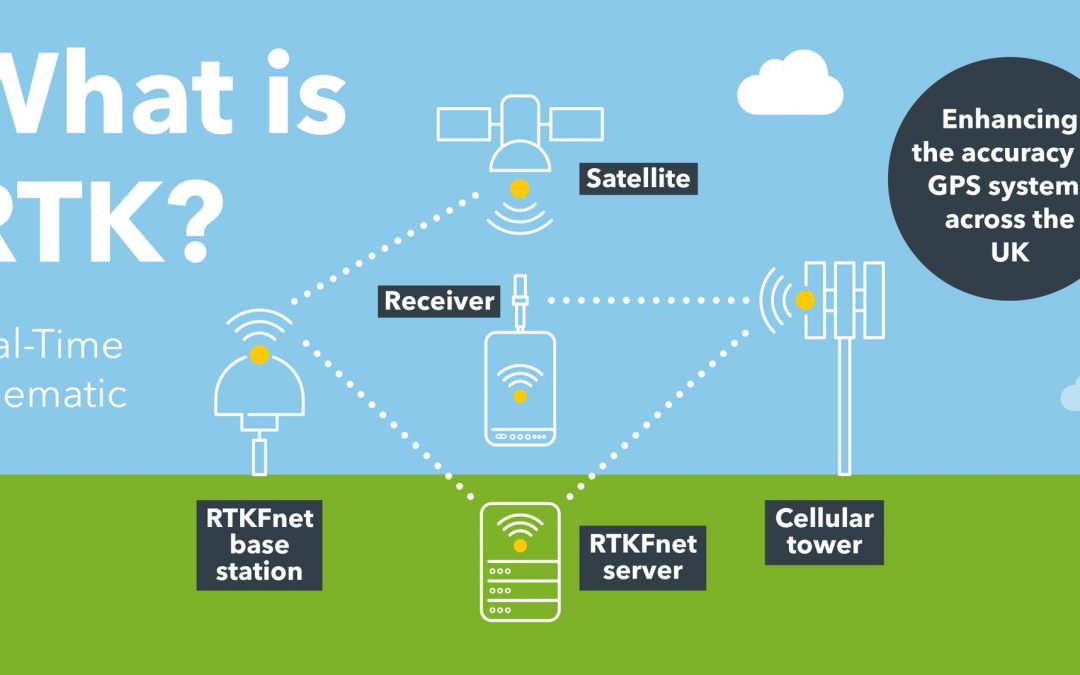
At the core of RTK technology is the concept of differential positioning. In a standard GNSS setup, the accuracy is limited by factors like atmospheric interference and satellite clock errors. RTK overcomes these limitations by comparing the position of a stationary reference station with a mobile rover station in real-time.
Here’s a simplified breakdown of the process:
1. Reference Station Setup: A stationary reference station, equipped with a high-precision GNSS receiver, continuously receives signals from satellites overhead. This station precisely calculates its own position.
2. Correction Data Transmission: The reference station calculates the difference between its known position and the GNSS signals it receives. This correction data, containing information to correct errors, is then transmitted in real-time to the rover station.
3. Rover Station Receives Corrections: The mobile rover station, also equipped with a GNSS receiver, receives the correction data from the reference station. By applying these corrections to its GNSS data, the rover achieves centimeter-level accuracy in real-time.
4. Achieving Centimeter-Level Accuracy: With the real-time corrections, the rover station can determine its precise position with centimeter-level accuracy, overcoming the inaccuracies associated with atmospheric conditions and other factors.
Significance in Precision Positioning
The significance of RTK signals lies in their ability to provide unparalleled accuracy and reliability in positioning. This has transformative effects across various industries:
1. Precision Agriculture:
- RTK enables farmers to precisely navigate tractors and equipment, optimizing resource use and minimizing overlap. This accuracy is crucial for tasks like planting, harvesting, and fertilizing.
2. Surveying and Mapping:
- Surveyors benefit from RTK’s accuracy in mapping landscapes and infrastructure. This technology streamlines the surveying process, reducing the need for manual measurements and ensuring the precision of cadastral surveys.
3. Autonomous Vehicles:
- In the realm of autonomous vehicles, RTK signals play a pivotal role in ensuring safe and accurate navigation. Self-driving cars, drones, and robots rely on real-time corrections to navigate complex environments with precision.
4. Construction and Engineering:
- RTK technology enhances construction projects by providing precise location data for heavy machinery and ensuring that structures are built according to exact specifications.
5. Environmental Monitoring:
- RTK signals aid in environmental research by providing accurate location data for monitoring changes in ecosystems and studying the impact of climate change.
In conclusion, RTK signals are a game-changer in the world of precision positioning. By understanding the basics of how they work and their significance in various industries, you’re well on your way to appreciating the transformative power of RTK technology. Whether you’re a farmer optimizing crop management or a surveyor mapping new terrain, the precision offered by RTK signals opens up a world of possibilities for accurate and efficient location-based applications.
